Abstract
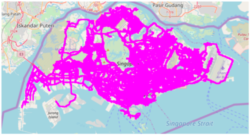
Real-world GPS trajectory datasets are essential for geographical applications such as map inference, map matching, traffic detection, etc. Currently only a handful of GPS trajectory datasets are publicly available and the quality of these datasets varies. Most of the existing datasets have limited geographical coverage (a focus on China or the USA), have low sampling rates and less contextual information of the GPS pings. This paper presents Grab-Posisi, the first GPS trajectory dataset of Southeast Asia from both developed countries (Singapore) and developing countries (Jakarta, Indonesia). The data were collected very recently in April 2019 with a 1 second sampling rate, which is the highest amongst all the existing open source datasets. It also has richer contextual information, including the accuracy level, bearing, speed and labels trajectories by data acquisition source (Android or iOS phones) and driving mode (Car or Motorcycle). The dataset contains more than 88 million pings and covers more than 1 million kms. Experiments on the dataset demonstrate new challenges for various geographical applications. The dataset is of great value and a significant resource for the community to benchmark and revisit existing algorithms.
Read the paper here
See Grab’s Blogpost about this paper here
Written by: Zhengmin Xu, Poornima Badrinath, Xiaocheng Huang, Abeesh Thomas
Published in: PredictGIS’19: Proceedings of the 3rd ACM SIGSPATIAL International Workshop on Prediction of Human Mobility, November 2019

Abstract
Real-world GPS trajectory datasets are essential for geographical applications such as map inference, map matching, traffic detection, etc. Currently only a handful of GPS trajectory datasets are publicly available and the quality of these datasets varies. Most of the existing datasets have limited geographical coverage (a focus on China or the USA), have low sampling rates and less contextual information of the GPS pings. This paper presents Grab-Posisi, the first GPS trajectory dataset of Southeast Asia from both developed countries (Singapore) and developing countries (Jakarta, Indonesia). The data were collected very recently in April 2019 with a 1 second sampling rate, which is the highest amongst all the existing open source datasets. It also has richer contextual information, including the accuracy level, bearing, speed and labels trajectories by data acquisition source (Android or iOS phones) and driving mode (Car or Motorcycle). The dataset contains more than 88 million pings and covers more than 1 million kms. Experiments on the dataset demonstrate new challenges for various geographical applications. The dataset is of great value and a significant resource for the community to benchmark and revisit existing algorithms.
Read the paper here
Written by: Yifang Yin, Abhinav Sunderrajan, Xiaocheng Huang, Jagannadan Varadarajan, Guanfeng Wang, Dhruva Sahrawat, Ying Zhang, Roger Zimmermann, See-Kiong Ng
Published in: GeoAI 2019: Proceedings of the 3rd ACM SIGSPATIAL International Workshop on AI for Geographic Knowledge Discovery November 2019
Abstract
The quality of a digital map is of utmost importance for geo-aware services. However, maintaining an accurate and up-to-date map is a highly challenging task that usually involves a substantial amount of manual work. To reduce the manual efforts, methods have been proposed to automatically derive road attributes by mining GPS traces. However, previous methods always modeled each road attribute separately based on intuitive hand-crafted features extracted from GPS traces. This observation motivates us to propose a machine learning based method to learn joint features not only from GPS traces but also from map data. To model the relations among the target road attributes, we extract low-level shared feature embeddings via multi-task learning, while still being able to generate task-specific fused representations by applying attention-based feature fusion. To model the relations between the target road attributes and other contextual information that is available from a digital map, we propose to leverage map tiles at road centers as visual features that capture the information of the surrounding geographic objects around the roads. We perform extensive experiments on the OpenStreetMap where state-of-the-art classification accuracy has been obtained compared to existing road attribute detection approaches.
Written By: Yifang Yin, Guanfeng Wang, Dhruva Sahrawat, Jagannadan Varadarajan, Roger Zimmermann, See-Kiong Ng
Under Review for WWW2020. See presentation here
Abstract
Real-world GPS trajectory datasets are essential for geographical applications such as map inference, map matching, traffic detection, etc. Currently only a handful of GPS trajectory datasets are publicly available and the quality of these datasets varies. Most of the existing datasets have limited geographical coverage (a focus on China or the USA), have low sampling rates and less contextual information of the GPS pings. This paper presents Grab-Posisi, the first GPS trajectory dataset of Southeast Asia from both developed countries (Singapore) and developing countries (Jakarta, Indonesia). The data were collected very recently in April 2019 with a 1 second sampling rate, which is the highest amongst all the existing open source datasets. It also has richer contextual information, including the accuracy level, bearing, speed and labels trajectories by data acquisition source (Android or iOS phones) and driving mode (Car or Motorcycle). The dataset contains more than 88 million pings and covers more than 1 million kms. Experiments on the dataset demonstrate new challenges for various geographical applications. The dataset is of great value and a significant resource for the community to benchmark and revisit existing algorithms.
Read the paper here
Written by: Yifang Yin, Abhinav Sunderrajan, Xiaocheng Huang, Jagannadan Varadarajan, Guanfeng Wang, Dhruva Sahrawat, Ying Zhang, Roger Zimmermann, See-Kiong Ng
Published in: GeoAI 2019: Proceedings of the 3rd ACM SIGSPATIAL International Workshop on AI for Geographic Knowledge Discovery November 2019 (Best Paper Award)
Abstract
Real-world GPS trajectory datasets are essential for geographical applications such as map inference, map matching, traffic detection, etc. Currently only a handful of GPS trajectory datasets are publicly available and the quality of these datasets varies. Most of the existing datasets have limited geographical coverage (a focus on China or the USA), have low sampling rates and less contextual information of the GPS pings. This paper presents Grab-Posisi, the first GPS trajectory dataset of Southeast Asia from both developed countries (Singapore) and developing countries (Jakarta, Indonesia). The data were collected very recently in April 2019 with a 1 second sampling rate, which is the highest amongst all the existing open source datasets. It also has richer contextual information, including the accuracy level, bearing, speed and labels trajectories by data acquisition source (Android or iOS phones) and driving mode (Car or Motorcycle). The dataset contains more than 88 million pings and covers more than 1 million kms. Experiments on the dataset demonstrate new challenges for various geographical applications. The dataset is of great value and a significant resource for the community to benchmark and revisit existing algorithms.
Read the paper here
See Grab’s Blogpost about this paper here
Written by: Zhengmin Xu, Poornima Badrinath, Xiaocheng Huang, Abeesh Thomas
Published in: PredictGIS’19: Proceedings of the 3rd ACM SIGSPATIAL International Workshop on Prediction of Human Mobility, November 2019 (Honorable Mention)
Abstract
The proliferation of modern GPS-enabled devices like smartphones have led to significant research interest in large-scale trajectory exploration, which aims to identify all nearby trajectories of a given input trajectory. Trajectory exploration is useful in many scenarios, for example, in identifying incorrect road network information or in assisting users when traveling in unfamiliar geographical regions as it can reveal the popularity of certain routes/trajectories. In this study, we develop an interactive trajectory exploration system, named TraV. TraV allows users to easily plot and explore trajectories using an interactive Graphical User Interface (GUI) containing a map of the geographical region. TraV applies the Hidden Markov Model to calibrate the user input trajectory and then makes use of the massively parallel execution capabilities of modern hardware to quickly identify nearby trajectories to the input provided by the user. In order to ensure a seamless user experience, TraV adopts a progressive execution model that contrasts to the conventional query-before-process model. Demonstration participants will gain experience with TraV and its ability to calibrate user input and analyze billions of trajectories obtained from Grab drivers in Singapore.
Read the paper here
Written by: Jieliang Ang, Tianyuan Fu, Johns Paul, Shuhao Zhang, Bingsheng He, Teddy Sison David Wenceslao, Sien Yi Tan
Published in: Fifth IEEE International Conference on Multimedia Big Data (BigMM), 2019
Abstract
In the last decade, many researchers and applications focused on street view systems’ geo-spatial and multimedia content. However, most street view systems have high data collection costs and have out of date content in certain regions. An efficient and effective street view system reflecting real world multimedia content on a weekly basis has been an elusive goal. We present GrabView, a street view system that: · Uses a data capture during ride sharing service trips model. · Collects up-to-date geo-referenced multimedia content atlow cost. · Processes both the multimedia and geo-sensor content. · Serves a navigation and browsing user experience equivalent to that from dedicated mapping vehicles. Grab ride hailing service vehicles collect most of GrabView’s geo-sensor data and multimedia content. This results in much better up-to-the-minute road network coverage at no extra cost.
Read the paper here
Written by: Jiong Huang, Sheng Hu, Yun Wang, Chunhong Zhao, Guanfeng Wang, Xudong He, Xiaocheng Huang, Shaolin Zheng, Tom Galloway, Yifang Yin, Roger Zimmermann
Published in: Fifth IEEE International Conference on Multimedia Big Data (BigMM), 2019 (Best Demo Award)

Abstract
Grab is a Singapore-based technology company offering ride-hailing transport service, food delivery and payment solutions for Southeast Asia. One crucial part of transport service is to provide users with desired POIs as pickups and dropoffs based on their locations with as less effort as possible, which can be measured by the clicking times on the screen before clicking the booking button. As a geo-based service, POI (point of interest) discovery and recommendation involves a lot of geometric calculation and high traffic throughput. It is important to ensure the high availability and stability of POI discovery and recommendation. We adapt Golang-based service architecture to ensure the stability of the backend system. Elastic search is utilized to organize millions of POI data on the database layer. Redis is used to shorten the response time of each request as cache. In this paper, we will introduce our Golang-based service architecture and how we tackle the online challenges by deploying cutting-edge techniques such as Elastic Search and Redis according to unique business scenarios.
Read the paper here
Written by: Qing Fan, Lang Jiao, Chengcheng Dai, Ziqiang Deng, Rui Zhang
Published in: 2019 20th IEEE International Conference on Mobile Data Management (MDM)

Abstract
Locating nearest moving objects in real-time is a vital problem that the ride-hailing industry needs to address. For instance, when a passenger makes a booking, the service provider, such as Grab or Uber, needs to locate the K nearest drivers for the given pickup location in case the closest driver is not optimal for this booking request. This poses two main challenges: firstly, massive frequent write operations are needed to track the objects’ current locations. As drivers can move as fast as 25 meters per second in developed countries like Singapore, it is therefore important to update drivers’ locations at a second, if not millisecond, granularity. Secondly, a K-nearest neighbour (kNN) query poses tremendous challenges, compared to a simple Get query, in a key-value data store such as Redis. This paper presents Sextant, a scalable in-memory spatial data store tailored for kNN searches. Sextant is decentralized, scalable, reliable, efficient and highly available. It has been supporting Grab’s daily flow with no downtime for more than one year, with write QPS (query per second) and kNN query QPS approaching millions.
Read the paper here
Written by: Zhiyin Zhang, Xiaocheng Huang, Chaotang Sun, Shaolin Zheng, Bo Hu, Jagannadan Varadarajan, Yifang Yin, Roger Zimmermann, Guanfeng Wang.
Published in : 2019 20th IEEE International Conference on Mobile Data Management (MDM)
Abstract
The available prior demand data will make it possible for the ride hailing platform to make the central control strategies, which plan a sequence of trips for drivers in a certain future time period, so that a system optimal vehicle dispatch could be achieved. However, handling a large scale booking requests within the restrictive computing time to achieve an optimal vehicle dispatch is a big challenge. This paper proposes an optimization framework for the online vehicle dispatch problem by adopting vehicle scheduling methodology. A novel approach is introduced to solve the optimization challenges of the large problem size and the limited computing time. The designed optimization framework is validated by the real-world demand data in Singapore.
Read the paper here
Written by: Kangjia Zhao, Wenqing Chen, Kong Wei Lye
Published in : 2018 IEEE International Conference on Data Mining Workshops (ICDMW)
Abstract
Accurate travel time estimation is crucial for several service based industries such as ride hailing, food delivery, logistics etc. Promises made to the passengers in terms of cab allocation, waiting times and food delivery times need to be kept to avoid passenger churn given the number of competing start-ups in these sectors. Further, travel times impact the cost of the cab rides and delivery charges which are shown upfront to the passengers and drivers. Trip time estimations must thus be very accurate to avoid both passenger and driver disenchantment. In this paper we present a solution for accurate upfront TTE based on RSP and a corrective ML model using data from around 9.5 million taxi trips in two (each) mega-cities in S.E Asia.
Read the paper here
Written by: Abhinav Sunderrajan, Jagannadan Varadarajan, Kong Wei Lye
Published in : 2018 IEEE International Conference on Data Mining Workshops (ICDMW)